Past work and research
Sensing, signal processing, and navigation
Nalu Technology began with research into how small unmanned aircraft can know where they are, and detect each other, using low-cost sensors and AI-based sensor fusion. That work shaped how we build products today.
Positional Awareness in GPS-Denied Environments
A navigation system that estimated the position of a small drone when GPS was unavailable or unreliable, by fusing radio, camera, and inertial data.
Small unmanned aircraft depend on GPS, and GPS can be jammed, spoofed, or simply blocked indoors and in dense terrain. This project set out to give a small drone a reliable estimate of its own position without it, and without prior knowledge of its starting location, landmarks, or the signals around it.
Three independent sources
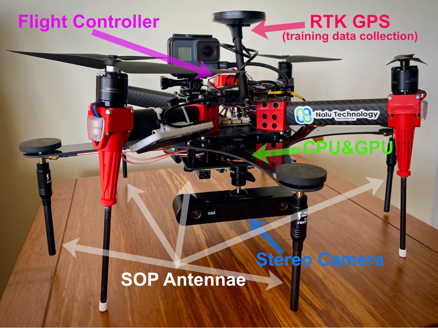
Signals of opportunity. Five phase-coherent software-defined radios, all driven from a single clock and paired with five omnidirectional antennas, measured the direction of radio signals already present in the environment. Correlative interferometry and the MUSIC algorithm turned those measurements into bearings for triangulation.
Visual odometry. A stereo camera and NVIDIA embedded computing estimated the drone’s motion from sequential images in real time: image capture, SIFT feature extraction, brute-force feature matching, then motion estimation in X, Y, and Z.
Inertial and environmental sensing. Onboard motion and environmental sensors provided a continuous, high-rate estimate between the slower radio and camera updates.
Fusion
An error-state extended Kalman filter fused the visual odometry and inertial data, and a neural network learned the harder, non-linear relationships between all three sources. Training data came from an RTK GPS receiver on the test platform, which recorded ground truth position during test runs. Combining the sources raised the signal-to-noise ratio and reduced the uncertainty and ambiguity that any single sensor carried on its own.
-
Signals of opportunity
- Five phase-coherent SDRs on one clock
- Correlative interferometry
- MUSIC direction finding
-
Visual odometry
- Stereo camera
- SIFT features, brute-force matching
- NVIDIA embedded computing
-
Inertial and environmental
- Motion sensors (IMU)
- Environmental sensors
- High-rate updates between fixes
Sensor fusion
- Error-state extended Kalman filter
- Neural network for non-linear effects
Trained against RTK GPS ground truth
Position estimate
Relative position without GPS, landmarks, or a known start point
Approach
The work followed a staged development process, from exploration and requirements through a detailed design phase with two full prototypes, then verification. Each stage had a clear exit test before the next began.
- Phase 0 Exploration
- Phase 1 Requirements and Planning
- Phase 2 Detailed Design
- Architecture and technology feasibility
- Prototype 1: design, build, and test
- Prototype 2: design, build, and test
- Phase 3 Verification
- Release Production
Light Tactical Vehicle Drone Detection
An exploration of a low-cost device to detect small drones from a light tactical vehicle, using radio triangulation and computer vision.
Small Group 1 drones, those under about 20 pounds, flying below 1,200 feet and slower than 115 miles per hour, are inexpensive and hard to see. They pose a real threat to small teams and squads.
This exploration looked at whether the same building blocks used in the navigation work, software-defined radio triangulation and computer vision, could be combined into an affordable detector mounted on a light tactical vehicle. Radio sensing would locate a drone’s control and video links, and camera-based detection would confirm and track the aircraft.
Recognition
Research recognition
- 2022Accepted into NVIDIA Inception
- 2022U.S. Army xTechDetect finalist, one of twelve
- 2022NIST UAS Indoor Challenge, phase one winner
- 2023xTechPacific white paper winner and pitch semifinalist
- 2023Selected to demonstrate at Army Research Laboratory Tech Assess '23